Snowpack drastically improving over last year
Recent snow in the Colorado mountains has caused snowpack totals in many of the state’s river basins to be much higher than it was during the same time last year. This is great news for a state that has struggled with fire and drought conditions.
There has been measurable snow on 15 of the last 21 days in the mountains and the result is a generally healthy snowpack map. Of the eight river basins in Colorado, five of them have above-normal snowpack and two of them are near normal including the South Platte basin which includes the Denver, Boulder, and Fort Collins areas. The Arkansas and Upper Rio Grande basins in southern Colorado remain below normal largely because most of the recent snow has missed the Sangre de Cristo mountains adjacent to Pueblo, Walsenburg, and Trinidad. However, the good news is snow is in the forecast in the coming days for the southern region. 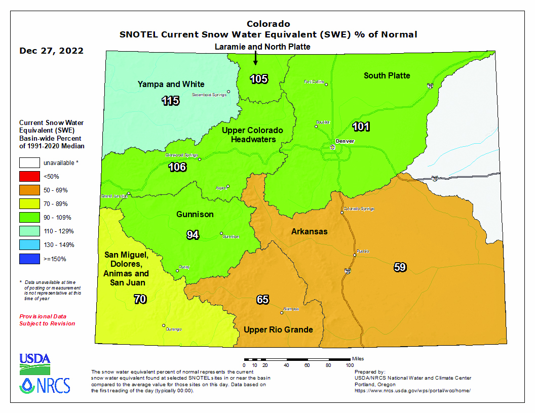
Snowpack is critically important to Colorado’s water supply since the majority of water used in the state begins as snowpack. A good snowpack in the winter months usually translates into less significant drought and fewer water restrictions in the summer months, good news for everyone in Colorado. It also can mean fewer wildfires in the months following a winter with consistently good snowpack.
The National Water and Climate Center (NWCC), located in Portland, Oregon, supports the Snow Survey and Water Supply Forecasting Program which keeps track of the snowpack along with accessible water forecasts. As part of the USDA’s Natural Resources Conservation Service, the NWCC is responsible for producing and disseminating accurate and reliable water supply forecasts and other climatic data to its wide variety of users.
All the data collected at the National Water and Climate Center are quality-controlled and placed in a comprehensive database known as the Water and Climate Information System (WCIS).
In addition to the data collected through the automated SNOTEL and manual snow data collection processes, the NWCC also incorporates precipitation, streamflow, and reservoir data from the U.S. Army Corps of Engineers (USACE), the U.S. Bureau of Reclamation (BOR), the Applied Climate Information System (ACIS), the U.S. Geological Survey (USGS), various water districts and other entities into the Water and Climate Information System database.
New snowfall across Colorado as of Wednesday, with places like Spud Mountain receiving up to 9” of new snowfall, raised snowpack levels up to 35”. Snowpack levels across the state are on average currently 101% of normal with 417 locations reporting. The deepest snowpack in Colorado was last observed at Summit Ranch reporting a snowpack depth of 176”, about 666% of normal when compared to their 26″ average depth for this time of year.
Mineral Creek, perched at an elevation of 10,040ft, is currently experiencing some of the coldest temps in Colorado with air temps last recorded at 23 degrees. More snowfall is expected this week, and areas like Cascade #2 are slated to receive up to 35″ of snowfall in the next 5 days.
- March, 01 2018

The 2018 precinct caucus will take pl...
By Amber McIver-Traywick The Surveyor If you are currently a registered Democrat or Republican in...
- October, 29 2015
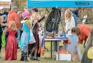
Treat-on-the-Street festivities 2015
By May Soricelli The Surveyor Locals participate in Halloween festivities at...
- June, 14 2019

15 Years
By Becky Justice Hemmann The Surveyor It’s hard to believe 15 years have gone by....
- November, 25 2020

CASA faces increased need for volunte...
Before the onset of the COVID-19 pandemic, CASA of Larimer County aimed to train another...
- June, 01 2023

Family movie nights return to Fickel ...
By Terry Georgia The Surveyor Movie nights are returning to Fickel Park this summer with...
- January, 11 2019
Berthoud drug has new owners, as form...
By Amber McIver-Traywick The Surveyor Berthoud Drug has been a staple in the community for...


Unified basketball comes to Turner Middle School
Community News
Mike Grace says goodbye as Brett Wing joins town board
Community NewsPOLICEBLOTTER
Community NewsNorthern Water sets C-BT quota at 70% for 2024
Community News
Emotions run high during Revere Property hearing
Community NewsSnowpack at 119% above normal
Community NewsKarspeck to serve third term as Berthoud mayor
Community News
COMMUNITY CALENDAR:
Community Calendar – add an event
Homestead Fine Art Gallery First Fridays OPEN HOUSE
03 May 4:00 PM - 7:00 PMHomestead Fine Art Gallery First Fridays OPEN HOUSE
07 Jun 4:00 PM - 7:00 PMHomestead Fine Art Gallery First Fridays OPEN HOUSE
05 Jul 4:00 PM - 7:00 PMHomestead Fine Art Gallery First Fridays OPEN HOUSE
02 Aug 4:00 PM - 7:00 PMHomestead Fine Art Gallery First Fridays OPEN HOUSE
06 Sep 4:00 PM - 7:00 PMHomestead Fine Art Gallery First Fridays OPEN HOUSE
04 Oct 4:00 PM - 7:00 PM