Mountain Avenue Corridor Overlay Plan approved by Planning Commission
By Rudy Hemmann
The Surveyor
The Berthoud Planning Commission held a regularly scheduled meeting on the evening of Thursday, Nov. 14, 2019, to conduct a public hearing concerning the Mountain Avenue Corridor Overlay Plan (Plan).
According to an information sheet provided by town staff, on Nov. 11 of this year the town board unanimously approved the Plan following a similar unanimous recommendation by the planning commission. The town board also accepted the planning commission’s recommendation to have the two consulting firms working on the Plan, BHA Design and ALM2S Architects, put their heads together and reimagine the wayfinding and gateway signage.
The firms named above have been working with town staff for more than a year to bring the Plan to this stage of development. Town staff has prepared code language to make the plan a reality and not just a vision.
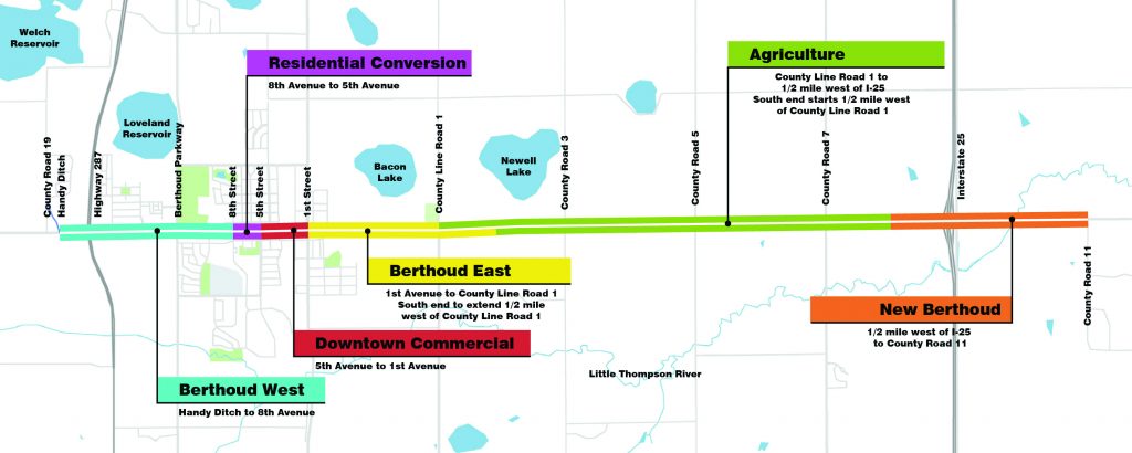
The Plan has divided Mountain Avenue into six sections (or transects) with each section focused on protecting and enhancing the existing historical districts and directing the general character of new development along Mountain Avenue and Highway 56. The boundary of the Plan will be applicable to all properties within 150 feet measured from the centerline of Highway 56.
The sections and a brief description of each, beginning with the western end of the Plan and moving eastward follows: (Much of the following information is from a presentation given by the design team.)
Berthoud West; This is a largely undeveloped district with views of the Rocky Mountains, and in close proximity to downtown and Highway 287. This area is envisioned as a vibrant walkable commercial district with opportunities for shopping, employment and other services. Though this district is in close proximity to the town core, it will build on the unique characteristics of downtown, but not replicate it.
The Berthoud West section extends from approximately 800 feet west of Highway 287 eastward to Eighth Street.
Residential Conversion; This district is characterized by charming older homes occupied by businesses and commercial uses. Majestic street trees create a seemingly continuous canopy over Mountain Avenue, and expanded green spaces surrounding the homes and detached walks with tree lawns create a walkable neighborhood. Preservation of historic homes is encouraged.
This section extends along Mountain Avenue from Eighth Street to Fifth Street.
Downtown Commercial; Berthoud’s Downtown District represents a concentration of character and personality, and shapes much of the town’s identity. Its buildings give a sense of history, its businesses and restaurants show the liveliness of the town, and its quirks set it apart from other towns in northern Colorado.
The Downtown Commercial district extends along Mountain Avenue between Fifth Street and First Street in the downtown area.
Berthoud East; This section is viewed as a transition district from the rural agrarian areas to the downtown core. The undeveloped land on the south side of Highway 56 is envisioned as a vibrant walkable residential district with a mixed-use area near the intersection of County Line Road providing opportunities for shopping, dining, employment and other services.
This section includes parcels that are located within the following: Along the north side of Highway 56 from First Street to County Line Road, along the south side of Highway 56 from First Street to a point one half mile east of County Line Road.
Agriculture; Farms, big skies, distant views, and scattered farmsteads provide a pleasant separation between Interstate 25 and the town, which adds to Berthoud’s small-town appeal. The primary goal of this district is to retain the rural and agrarian character and to protect the iconic views to the Rocky Mountains.
The Agriculture section varies on the north and south frontages. Along the north side of Highway 56 the section extends from County Line Road to a point approximately one-half mile west of I-25. Along the south side of Highway 56 from a point one-half mile east of County Line Road to a point approximately one-half mile west of I-25.
New Berthoud; This section straddles the I-25/Highway 56 interchange and is the gateway into town. The lasting impression should relate to “Berthoud Proper” and offer a fresh new twist.
The Agriculture Character District extends ½ mile west of I-25 to CR 11. Expansive master planned developments are anticipated in the New Berthoud District with large scale retail/lifestyle uses near the 1-25/Mountain Avenue interchange, then transitioning to mixed-use and residential developments further from the I-25 roadway and interchange.
A motion recommending the town board approve the code and zoning changes for the Mountain Avenue Overlay Plan, was made, seconded and passed unanimously with the following conditions.
- Clean up typographical and grammatical errors.
- Remove the language regarding on-street parking restrictions in all districts.
- Remove the entire sentence Item 1 regarding discouraging changes to historic homes in the residential transition district.
- Remove third-story step-back requirements.
- March, 22 2018

Thompson School District announces fi...
Special to the Surveyor The Thompson School District Board of Education is pleased to announce...
- May, 31 2019

New playground equipment ordered for ...
By Rudy Hemmann The Surveyor Tuesday evening’s meeting of the town trustees began an hour...
- May, 01 2020
Trustees approve Local Business Relie...
By Rudy Hemmann The Surveyor The Berthoud Board of Trustees held a regular business meeting...
- March, 27 2020

U.S. Census taking place now – ...
By Amber McIver-Traywick The Surveyor The U.S. Census Bureau released the initial response rates for...
- May, 17 2019

Man arrested in Berthoud for firing w...
By Amber McIver-Traywick The Surveyor Late Friday night, May 10, a former employee of the...
- November, 23 2022

Mountain View Farmstead: A breed apart
Courtesy photo - Scottish Highland Cattle at Mountain View Farmstead in...


Unified basketball comes to Turner Middle School
Community News
Mike Grace says goodbye as Brett Wing joins town board
Community NewsPOLICEBLOTTER
Community NewsNorthern Water sets C-BT quota at 70% for 2024
Community News
Emotions run high during Revere Property hearing
Community NewsSnowpack at 119% above normal
Community NewsKarspeck to serve third term as Berthoud mayor
Community News
COMMUNITY CALENDAR:
Community Calendar – add an event
Homestead Fine Art Gallery First Fridays OPEN HOUSE
03 May 4:00 PM - 7:00 PMHomestead Fine Art Gallery First Fridays OPEN HOUSE
07 Jun 4:00 PM - 7:00 PMHomestead Fine Art Gallery First Fridays OPEN HOUSE
05 Jul 4:00 PM - 7:00 PMHomestead Fine Art Gallery First Fridays OPEN HOUSE
02 Aug 4:00 PM - 7:00 PMHomestead Fine Art Gallery First Fridays OPEN HOUSE
06 Sep 4:00 PM - 7:00 PMHomestead Fine Art Gallery First Fridays OPEN HOUSE
04 Oct 4:00 PM - 7:00 PM